The latest bulletin from the National Hurricanes Center (NHC) indicates that the system has not yet been able to close its eye, and thus remains cyclone potential No. 2. However, NOAA claims its classification as a tropical storm may come that in any time, because it has strong bands of rain and strong winds near the threshold of Tropical Storm.
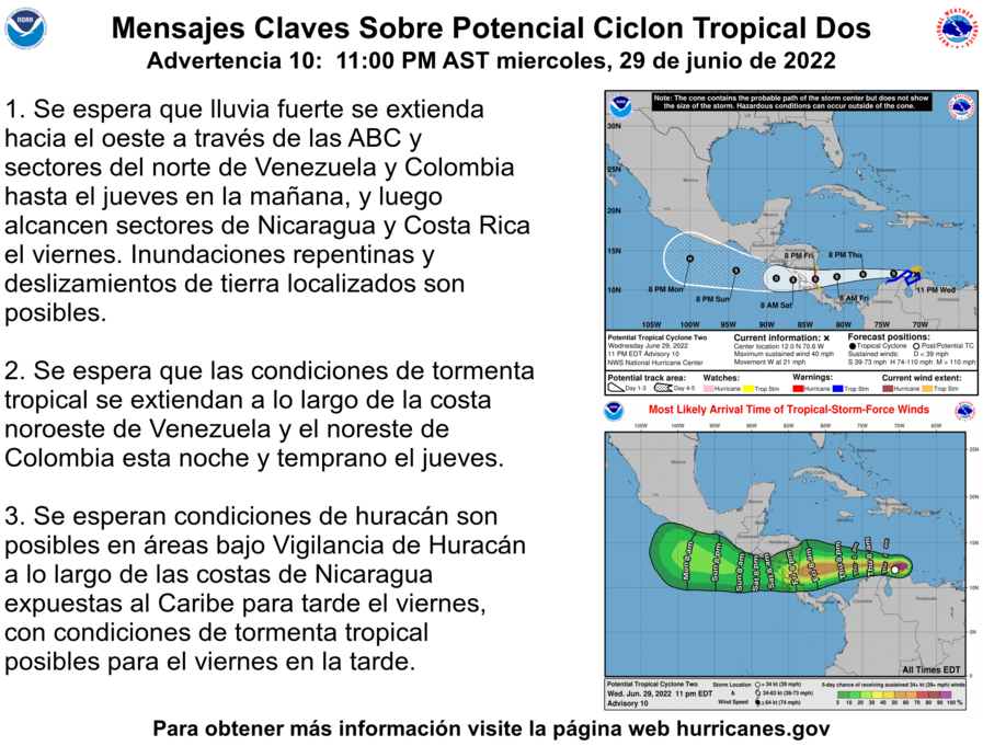
The trajectory is towards the border between Nicaragua and Costa Rica and in the last elaborations it has moved further south, so it is possible that in the next few days it will hit the Caribbean coasts.
A hurricane surveillance warning was issued for the border area between Nicaragua and Costa Rica. In addition, a Tropical Storm early warning was issued from Limon north to the Nicaragua-Costa Rica border.
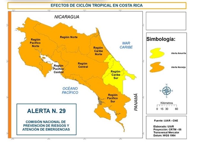
The National Risk Prevention Commission CNE has declared Orange Alert for the whole Pacific, the Central Valley, the North Zone and the Northern Caribbean. A yellow alert has been issued for the Southern Caribbean.
The Ministry of Education (MEP) announced that on Friday the lessons will be suspended after noon, in order to safeguard the life of both the students and the administrative and teaching body.
Particular attention to the North Caribbean, North and North Pacific in the face of heavy rains expected from Friday and at least until Sunday. The same can intensify if the system continues to gain strength, as well as the presence of wind that can exceed 100 km / h. Likewise, caution to the Pacific and Central Valley area.
The Karen Mogensen Reserve area does not currently appear to be at risk of being directly affected, but may still be affected by precipitation bands linked or induced by the tropical cyclone, not yet officially named by NOAA NHC. Our weather station and webcam are in operation and will provide very interesting data, already the month of June with 560.4 mm so far collected by the rain gauge is detecting the wettest since our weather station is in operation.
Here the official forecast of the IMN:

Forecast: Rainy conditions are expected between Friday and Sunday due to the influence of this system in the country.
Heavy showers are expected on Friday mainly for the regions of the North Zone, the Caribbean and the Central and South Pacific, with quantities estimated (in 24 hours) around 100-200 mm for the Caribbean and the North Zone and around 100 mm for the Central and South Pacific
By Saturday, the rains should be concentrated mainly in the northern Caribbean, in the north, north of Guanacaste, as well as in the central and southern Pacific. Estimated amounts (24 hours) ranging from 100-250 mm for the northern part of the country and between 100-150 mm for the central and southern Pacific.
On Sunday, rainfall will be concentrated in the three Pacific regions with quantities estimated between 100-150 mm in 24 hours.
For the Central Valley, cloud cover is expected for the whole period with isolated precipitations and showers localized in mountainous sectors.