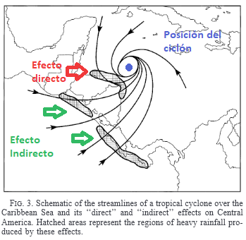
In the video you can see the time lapse of the webcam of the Karen Mogensen Reserve from 1 to 3 November 2020, with the formation and circulation of clouds and the wind induced by the indirect effects of Hurricane Eta, which impacted the coast of Nicaragua on the border with Honduras. Hurricane Eta did not hit Costa Rica, but its indirect effects were affected by continuous rains, especially on November 3. In the timelapse on day 1 we note the formation of mainly convective clouds, superimposed on bank transits of stratocumulus and nimbostrati. On day 2 the continuous changes of direction of the clouds are interesting, while on day 3 the cloud cover was uniform for nimbostrati and with continuous but overall not extraordinary rains.
On November 3, thanks to the coverage, the maximum temperature did not go beyond 23.7 ° C, which is the lowest maximum temperature recorded in 2020.
In detail, these are the rains that fell at Karen Mogensen at the Italia Costa Rica Station:
01/11/2020: 0.2 mm
02/11/2020: 20.4 mm
03/11/2020: 48.0 mm
the total is 68.6 mm, and now, November 4th, it is still raining.
Luca Lombroso – meteorologist